View Cart
0
Shop by Category
View Cart
0
Home Unmanned Autonomous Solutions Software PIX4DMATIC 3-YEAR OFFLINE LICENSE

PIX4DMATIC 3-YEAR OFFLINE LICENSE

Calculating price...
PART: 3030.302
SUPPLIER: PIX4D Inc
QUANTITY

About This Item:

PIX4Dmatic is desktop photogrammetry and surveying software for processing aerial and terrestrial imagery into geospatial data and CAD/GIS-ready deliverables. It supports large datasets, RGB imagery, multi-camera projects, LiDAR and RGB data from PIX4Dcatch, ground control points, checkpoints, coordinate reference systems, geoids, and site localization. Processing tools generate dense and depth point clouds, orthomosaics, digital surface models, 3D textured meshes, and other mapping outputs while providing control over calibration and reconstruction. 

PIX4Dmatic supports surveying, mapping, terrain modeling, volume measurement, construction and site documentation, and terrestrial mapping workflows. Users can create and classify point clouds, perform distance and volume measurements, vectorize project features, assess project accuracy, and export results for CAD and GIS workflows.


Bigger Datasets, Accurate Results
Process large aerial and terrestrial mapping datasets locally without splitting projects. PIX4Dmatic combines large-scale photogrammetry processing with tools for calibration, georeferencing, reconstruction, measurements, and survey data extraction.
 
Streamlined Processing
Use Nadir, Oblique, PIX4Dcatch, or Custom processing templates and control project calibration, dense point cloud generation, meshes, digital surface models, orthomosaics, and quality reporting. PIX4Dmatic also provides Auto-mark and AutoGCP tools to assist with project processing and accuracy workflows.
 
Terrestrial Workflow
Process LiDAR depth maps and RGB imagery from PIX4Dcatch for terrestrial mapping workflows. PIX4Dmatic can generate depth point clouds from PIX4Dcatch LiDAR data and combine depth and dense point clouds into a single reconstruction.


Large-Scale Processing:  Process large datasets locally using multicore CPU and GPU resources. PIX4Dmatic is designed to work with large mapping projects without requiring datasets to be divided into separate projects.

Easy Accuracy Checks:  Assess project accuracy using ground control points, checkpoints, Manual Tie Points, Intersection Tie Points, and other calibration tools. PIX4Dmatic provides 2D and 3D views for reviewing image and tie point positions, along with detailed Quality Reports for evaluating calibration and processing results.
 
Vertical Coordinate Systems and Geoid Support:  PIX4Dmatic supports known coordinate reference systems using EPSG or ESRI codes, local or site-specific coordinate systems, and commonly used geoid models. Site localization files in PRJ or WKT format can also be imported for custom coordinate reference systems.
 
Import from PIX4Dcatch:  Import and process LiDAR depth maps and RGB imagery from PIX4Dcatch for terrestrial workflows. PIX4Dmatic also supports site localization data generated with PIX4Dcatch.


Point Cloud
Generate a photogrammetric dense point cloud, create a depth point cloud from PIX4Dcatch LiDAR data, or combine depth and dense point clouds into a single reconstruction. Point clouds can also be classified using ASPRS classes and edited within PIX4Dmatic.
Orthomosaic
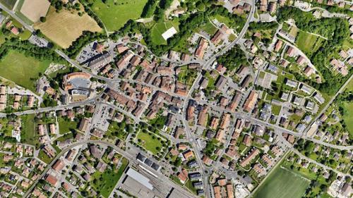
Generate an orthomosaic from the digital surface model and project imagery with controls for deghosting, oblique imagery, and image masks
Export Formats: LAZ, LAS 1.2, LAS 1.4, XYZ Export Formats: TIFF/GeoTIFF, TFW, PRJ, JPG, JGW


Digital Surface Model (DSM)
Generate a digital surface model from point cloud data with controls for resolution, surface smoothing, interpolation, and image masks.
Mesh
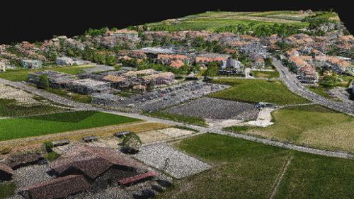
Generate a 3D textured mesh from point cloud data with configurable texture, decimation, smoothing, deghosting, and other processing parameters.
Export Formats: TIFF/GeoTIFF, TFW, PRJ Export Formats: OBJ, PLY, Cesium 3D Tiles, SLPK
 
 
Key Features:
  • Process aerial and terrestrial RGB imagery
  • Import LiDAR depth maps and RGB images from PIX4Dcatch
  • Support multiple cameras within the same project
  • Import GCPs, checkpoints, image geolocations, and orientation data
  • Support known, arbitrary, and site-specific coordinate reference systems
  • Support commonly used geoid models
  • Use Nadir, Oblique, PIX4Dcatch, and Custom processing templates
  • Automatically detect supported GCP targets with AutoGCP
  • Generate dense and depth point clouds and fuse them into a single point cloud
  • Generate 3D textured meshes, digital surface models, and orthomosaics
  • Review project data in 2D and 3D rayCloud views
  • Measure distances and volumes
  • Create markers, polylines, and polygons for project vectorization
  • Classify and edit point clouds using ASPRS classes
  • Assess calibration and processing results with Quality Reports
  • Export point clouds, meshes, DSMs, orthomosaics, geometries, and reports
  • Export processed PIX4Dmatic projects directly to PIX4Dsurvey


There are currently no specs for this product.

Qty 1- PIX4Dmatic License Offline (3-Year)