View Cart
0
Shop by Category
View Cart
0
Home 
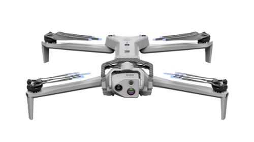
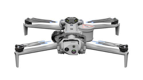
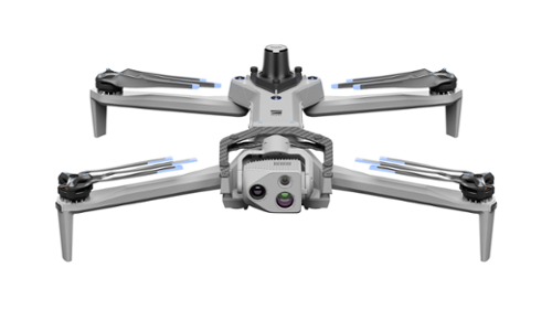
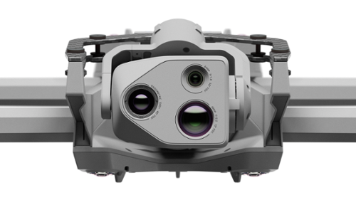
Unmanned Autonomous Solutions Aerial Drones NDAA/Blue Aircraft SKYDIO X10

SKYDIO X10

Calculating price...
Part SKYDIO-X10
QUANTITY

About This Item:

 
The Skydio X10 is a compact drone with advanced sensor options and autonomous AI designed to support accurate data collection in demanding conditions.
 

The Skydio X10 is an autonomous enterprise drone designed to support inspection, mapping, surveying, and public safety operations where accuracy, obstacle avoidance, and data reliability are required. It integrates advanced onboard computing, multiple sensor package options, and full 360‑degree obstacle avoidance to enable safe operation in complex environments such as infrastructure corridors, urban areas, and confined spaces. X10 is built for repeatable missions that require consistent data capture, including asset inspection, photogrammetry, and situational awareness, and is NDAA compliant, designed and assembled in the United States to meet federal sourcing requirements.

Skydio X10 supports key applications such as utility and infrastructure inspection, emergency response, search and rescue, site mapping, and remote visual assessment. With optional RTK and PPK support, X10 captures high‑precision geospatial data suitable for measurement and modeling workflows. Thermal imaging payload options enable temperature analysis and heat detection in low‑visibility conditions, supporting response and inspection tasks in environments affected by darkness, smoke, or weather. Its IP55 rating and rapid deployment capability allow operation across varied field conditions, while Skydio Cloud supports secure fleet management and data handling through SOC 2 Type II certified backend systems.


Advanced Imaging, Autonomous Flight, and Flexible Deployment
Visionary Camera. Precise Visual Data Capture.

Options include a 64 MP narrow camera, a 48 MP telephoto camera, a 50 MP wide camera with integrated flashlight, and a Teledyne FLIR Boson+ thermal sensor to support detailed visual and thermal data capture.

Designed to change how autonomous flight is experienced.

Piloting is straightforward due to its advanced autonomy and AI capabilities. With Skydio NightSense mode, the X10 can navigate autonomously in low‑light and dark conditions.

Built for flexible deployment in diverse environments.

Built on an open, modular platform, the Skydio X10 weighs under 4.7 pounds and supports 5G cellular connectivity for flexible deployment in a wide range of operating conditions.


Skydio X10: Designed to Perform in Demanding Conditions
Infrastructure Inspection

The Skydio X10 supports visual and thermal inspection of infrastructure assets by capturing high‑resolution imagery and temperature data, even in complex or confined environments. It is well suited for inspecting structures where close proximity, consistent data capture, and obstacle avoidance are required.

Mapping and Surveying

When equipped with optional RTK and PPK, the Skydio X10 captures precise geospatial data to support mapping, surveying, and 3D modeling workflows. This enables accurate photogrammetry and site documentation for planning and analysis.

Public Safety and Emergency Response

The Skydio X10 is used for public safety missions such as search and rescue, emergency response, and Drone as First Responder operations. Thermal imaging and autonomous navigation support situational awareness in low‑visibility and low‑light conditions.

Extended Overwatch and Reconnaissance

With long‑range visual and thermal sensor options, the Skydio X10 supports extended overwatch and reconnaissance tasks from safe standoff distances. This enables operators to monitor areas and track subjects without direct exposure to risk.


Docking Station for the Skydio X10

The Dock for Skydio X10 enables autonomous drone operations by positioning docked drones where work occurs and allowing teams to operate them remotely from anywhere. It supports applications ranging from real‑time situational awareness to scheduled asset inspections, delivering actionable data without on‑site personnel. Built for reliability in challenging environments, the system is designed for operation in rain, snow, wind, extreme heat, and cold, supporting BVLOS operations with onboard weather sensing, ADS‑B awareness, and autonomous flight capabilities.


Real‑Time Fleet Operations

Manage your fleet from a single interface, remotely operating drones with a clear, real‑time view of the operating area.

 
Unlimited Range Connectivity

Skydio Connect Fusion enables continuous flight operations by automatically switching between a point‑to‑point connection with the dock and 5G cellular connectivity. This ensures reliable control and an extended operational range wherever cellular coverage is available.

 
Remote Safety Controls

Enterprise‑grade safety features support remote pre‑flight checks, configurable surround lighting, and audible alerts to help manage operations safely without requiring on‑site personnel.


Skydio X10 Key Features:

  • NDAA Compliant: Designed, assembled, and supported in the U.S. to meet NDAA federal sourcing requirements.
  • SOC 2 Type II: Skydio Cloud is SOC 2 Type II certified for secure data handling and platform operations.
  • High‑resolution visible and thermal imaging with narrow, wide, telephoto, and radiometric thermal sensors
  • Onboard AI powered by NVIDIA Jetson Orin for autonomous flight with full situational awareness
  • Autonomous operation in daylight, low‑light, and dark conditions
  • Lightweight, foldable airframe under 4.7 lb with an open, modular design
  • Supports Wi‑Fi 6, LTE, and 5G cellular connectivity for extended‑range operations
  • True 360‑degree obstacle avoidance for complex environments
  • Operates in GPS‑denied and high‑EMI environments
  • Up to 40 minutes of flight time with sub‑40‑second deployment
  • IP55‑rated for dust and water resistance in outdoor conditions
  • Supports browser‑based flight and remote handoff to offsite pilots


Dock for Skydio X10 Key Features:

  • Supports Beyond Visual Line of Sight (BVLOS) operations with onboard weather sensing and ADS‑B awareness
  • Enables fully remote drone operations with no on‑site pilot required
  • Centralized control for managing and operating entire drone fleets
  • Automatic switching between dock radio and 5G with Skydio Connect Fusion for extended range
  • Remote pre‑flight checks, configurable lighting, and audible safety alerts
  • Rapid launch with aircraft airborne in approximately 20 seconds
  • Designed for continuous 24/7 operations, day or night
  • Built for harsh environments including rain, snow, wind, heat, and freezing temperatures
  • Operates across wide temperature and weather conditions
  • Weather‑protected, fixed deployment dock engineered for long‑term outdoor use


Skydio products include embedded software and cloud-enabled services subject to Skydio’s end user license and service terms. Customer use is governed by Skydio’s applicable legal terms available at https://www.skydio.com/legal.

SKYDIO X10 SPECIFICATION SHEET
DOCK FOR SKYDIO X10 SPECIFICATION SHEET
Weight (Including battery) 4.65 lb (connect SL) / 4.72 lb (connect SL & 5G)
Deployment Time Under 40 seconds
Maximum Flight Time Up to 40 miutes
Maximum Hover Time Up to 35 minutes
Maximum Flight Speed 45 mph
Airframe Design Foldable
Maximum Operational Range Up to 7.5 miles (connect SL) / Unlimited ( where 5G cellular coverage is available)
Obstacle Avoidance Coverage True 360°
Narrow Camera Resolution 64 MP
Wide Camera Resolution 50.3 MP
Telephoto Camera Resolution 48 MP
Thermal Camera Type Radiometric Thermal